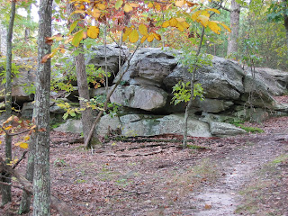
The trail is very pleasant and, as you can see below, quite rocky. There are large sandstone boulders everywhere. (I mistakenly referred to these as dolomite but was corrected by my friend Ted MacRae of Beetles in the Bush. Dolomite is a kind of limestone. The sedimentary rock in Hawn is apparently part of the Lamotte sandstone formation.) The terrain is quite steep in places as well. This picture was taken near the top of one of the two peaks I crossed during the hike.

The views of the surrounding area from the top were magnificent. The peak of fall color was just coming on.

As it began to get on toward evening I began looking for the campsite I had seen on the map. I found this spot right near a small creek which was quite lovely and had a fire ring and some sawn logs for sitting on. So I set up my hammock and made a fire. Interestingly the next morning I found the actual campsite a few hundred yards further down the trail. It had a sign that said "No Fires". Whoops! Oh well.

Below my hammock you can see a green underquilt that Debbie made for me. An underquilt keeps heat from escaping beneath you while you hang in the hammock. This one uses synthetic insulation and worked wonderfully.
The next morning I continued on to the other river that runs through the park, the Aux Valles. It runs alongside rocky cliffs for quite a while. Really gorgeous.

I had to get home fairly early so I bushwhacked to cut off some distance and get back sooner. That was fun but it ended up leading me to the edge of this cliff rather than to the parking lot. You can't tell the difference between a cliff and a hillside on a topographic map.

So I ended up having to climb down. Kind of scary actually. But I made it all right. At the bottom was Pickle Creek which I waded and then walked back to my car. I took this picture from the bottom. Does it look like a fun climb to do with a backpack on?
